


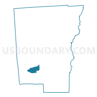
Voting District 060004, Chenango County, New York
About
Outline

Summary
| Unique Area Identifier | 626008 |
| Name | Voting District 060004 |
| County | Chenango County |
| State | New York |
| Area (square miles) | 9.57 |
| Land Area (square miles) | 9.47 |
| Water Area (square miles) | 0.10 |
| % of Land Area | 99.00 |
| % of Water Area | 1.00 |
| Latitude of the Internal Point | 42.33103130 |
| Longtitude of the Internal Point | -75.73392340 |
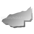
Maps


Graphs
Select a template below for downloading or customizing gragh for Voting District 060004, Chenango County, New York


Neighbors
Neighoring Voting District (by Name) Neighboring Voting District on the Map
- Voting District 040001, Chenango County, NY
- Voting District 060001, Chenango County, NY
- Voting District 060002, Chenango County, NY
- Voting District 060003, Chenango County, NY
- Voting District 150001, Chenango County, NY
- Voting District 150002, Chenango County, NY
Top 10 Neighboring County Subdivision (by Population) Neighboring County Subdivision on the Map
- Greene town, Chenango County, NY (5,604)
- Oxford town, Chenango County, NY (3,901)
- Coventry town, Chenango County, NY (1,655)